(http://maps.google.com/intl/en/help/maps/streetview/gallery/ocean/heron-island.html)
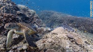
In September of 2012, Google Maps began adding StreetViews of many coral reefs and oceans. For those of you who aren't sure what StreetView, it's an interactive panorama feature within Google Maps. In September they added added panoramic undersea images of the Great Barrier Reef in Australia, the waters off the Apo Islands in the Philippines, underwater life around the Hawaiian islands and few other breathtaking places. These stunning panoramas allow us to experience schools of fish, turtles and breath-taking coral reefs, all from the comfort, safety and dryness of our homes. Viewers are able to zoom in and get a better look at schools of fish, intricate coral and even the belly of a manta ray. These panoramas are due to a partnership with the Catlin Seaview Survey, a group determined to create an archive of all the coral reefs.This partnership with Google is an attempt to get people to care about the fate of these beautiful ecosystems. These panoramas allow people who have never gone diving an introduction to the wonder. According to Richard Vevers, project director of the Catlin Seaview Survey, "It's about introducing to the wide number of people on this planet the impact we're having on these coral reefs. Until we make coral reefs and the important ecosystem in the ocean relevant to people on the planet, we're not going to get action." Future panorama sites will include Bermuda, the Caribbean, the Indian Ocean and the Coral Triangle, an area where coral reefs retreated to after the last ice age. I encourage all of you to take a look at these beautiful pictures and do your part in helping save the earth's coral reefs. The link is below, there are different reef options at the bottom of the page. I hope you enjoy it as much as I did!
http://maps.google.com/intl/en/help/maps/streetview/gallery/ocean/wilson-island.html
No comments:
Post a Comment